
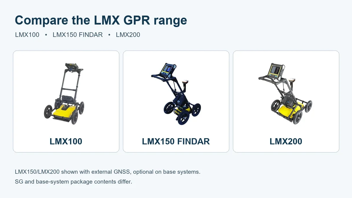
LMX100 vs LMX150 FINDAR vs LMX200: choosing a utility GPR system
Choose an LMX100 for a locate-and-mark workflow centred on cross-section views and screenshots. Compare LMX150 FINDAR and LMX200 when you need recorded lines, grids and project-data workflows. Then decide whether the job also requires an SG positioning package or a supported RTK configuration.
Start with the work and the information you need to retain. Radar interpretation, GNSS positioning and reporting software are different parts of the setup. A more precise coordinate does not make every buried target detectable, and a product photograph does not establish what is included in the order.
Compare the LMX workflows
| System | Selection focus | Consider it when |
|---|---|---|
| LMX100 | Cross-section views for locate-and-mark work, with saved screenshots | You need to investigate and mark responses in the field without a full recorded-line or grid-project workflow |
| LMX150 FINDAR | A compact system with recorded lines, grid collection and depth-slice workflows | Your work calls for the smaller-target, shallower-investigation role described for FINDAR, where the site permits a suitable response |
| LMX200 Enhanced | Utility-locating work with recorded lines and grids, mapping views and project-data output | You need to retain and review survey data rather than relying only on on-site marks and screenshots |
These are workflow distinctions, not guaranteed detection depths. Compare the exact system, supplied display configuration and outputs on the offer you choose. The wider GPR systems category also includes equipment and configurations for other survey tasks.
Decide what happens to the data
A screenshot records a view. Saved lines and grids let you retain a survey project for the supported review and export workflow. If your job requires post-processing or a particular report format, choose the system and software around that requirement before ordering.
The manufacturer’s current comparison distinguishes LMX100 screenshot output from the recorded project workflows on LMX150 FINDAR and LMX200. Do not assume that a screenshot-based workflow provides the same data as a saved project file, or that the same analysis licence applies to every LMX model.
Software is a separately paid option on the current base LMX150 FINDAR and LMX200 Enhanced offers. The selected software option determines the licence supplied. Compare the licence’s supported functions with the analysis and reporting work you intend to carry out; a hardware or GNSS package name alone does not establish a software entitlement.
Choose SG and RTK for the positioning workflow
The named SG configurations add the specified GNSS package to the corresponding radar system. The standard manufacturer listings distinguish LMX150SG and LMX200SG from the separate LMX150SG with RTK and LMX200SG with RTK configurations.
GNSS associates the radar survey with position information. An RTK workflow additionally needs supported correction data and the relevant configuration. The manufacturer’s GNSS specification states that a correction-service subscription is not included. Available services, connectivity, setup and charges depend on the provider and region.
Keep positioning quality separate from the radar result. Ground, target contrast, survey coverage and interpretation still determine what can be investigated. A coordinate does not by itself identify a utility, establish its depth accurately or prove that the ground is clear.
Compare the actual supplied equipment
The manufacturer’s standard system listings identify the display, sensor, cart, cable, battery, charger and spare-parts kit. The named SG configurations additionally identify the specified Geode package, mount and cable; the RTK configurations identify the upgraded positioning package. The exact seller offer and selected options establish the equipment supplied with the order.
Keep a transport case, a replacement display case, reporting software and correction-service access separate from that hardware list. Do not carry an included-item claim from an older promotion or another model into the offer you are comparing.
When comparing prices, compare equivalent equipment and selected options. A separately charged software selection or an added case can change the order total without changing the underlying radar model. The itemised offer matters more than the number of objects shown in a range photograph.
Choose supporting parts by role and model
Use the LMX accessory examples to separate power equipment, cables, wheels, displays, wear protection and transport. The LMX100/200 skid plate and LMX150 FINDAR skid plate are distinct products. Similarly, the LMX100/200 transit case and LMX150 FINDAR transit case have different named system scopes.
A single replacement wheel is not a wheel set. A main cable, battery cable and GNSS cable perform different jobs. A replacement display needs the supported model and generation, not merely a similar connector. Select the part for the equipment you actually have.
Legacy GPS accessories and current Geode SG packages are also different products. A mount or cable alone does not add the complete receiver, supported positioning functions or an RTK correction workflow.
Allow for the site and the target
GPR investigates reflections caused by contrasts in subsurface materials. Useful penetration depends strongly on the ground’s electrical properties as well as the equipment and target. Conductive ground can attenuate the signal; target size, depth, orientation and contrast affect whether a response is useful.
For a non-metallic pipe, GPR may be one suitable investigation method. Where appropriate access exists, a compatible sonde or traceable system can provide another approach. Read what a CAT and Genny cannot detect for the broader method-selection context, rather than treating GPR as an automatic answer to every quiet locator sweep.
Use locating equipment within a planned investigation and safe system of work, alongside service information and appropriate verification. A displayed depth range is not an excavation clearance, and an absent response does not prove an area is free of buried services.
Before choosing your system
- Identify the investigation and likely site conditions.
- Decide whether you need marks and screenshots, recorded projects or positioned survey records.
- Choose the corresponding radar model and exact configuration.
- Compare the supplied hardware and selected paid software option.
- Plan any required positioning service, connectivity and setup.
- Select compatible power, transport and replacement items by model and part number.
Browse GPR systems and GPR accessories together when building the setup.
Manufacturer references
The workflow comparison uses the manufacturer’s LMX model comparison and LMX range overview. See the manufacturer’s GPR-SG positioning information for supported positioning setup and the discussion of GPR penetration for site-dependence. The current GPR-SG technical specification V2 sets out positioning modes and correction-service exclusions. Use the instructions and technical documents for the exact equipment and revision supplied.
Manufacturer LMX range overview
This manufacturer range overview shows different LMX systems with earlier display and GPS hardware. LMX100 uses a screenshot-based workflow; recorded-project and positioning features demonstrated on other models do not apply to every LMX system. External GNSS and EKKO_Project desktop software are separate options on the base LMX150 FINDAR and LMX200 offers; the selected software is separately paid. SG and RTK contents follow the selected system listing, and correction-service subscriptions are separate. This video does not demonstrate the current Geode RTK setup.