
Radiodetection LMX100 GPR System | Utility Locating
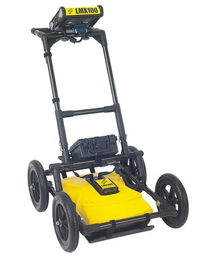
LMX100 ground penetrating radar for utility surveys, with a 250 MHz sensor, cart, display, battery and charger. View responses as you survey and save screenshots for field records. Detection depth depends on ground and target conditions.
What's in the Box
- LMX100 display unit.
- 250 MHz GPR sensor and cart.
- Standard wheel set.
- Display/main cable.
- LMX battery with power-source case.
- GPR battery charger.
- LMX spare parts kit.
Hard transport cases are separate accessories. The LMX100 workflow does not provide external GNSS input or raw GPR project export.
Follow utility responses in the field
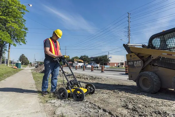
The LMX100 brings a 250 MHz ground penetrating radar sensor, wheeled cart and field display together for straightforward utility surveys. View subsurface responses as you move, investigate a suspected route and keep screenshots to support your field records.
Ground penetrating radar records reflections caused by changes in subsurface materials. It can help investigate metallic and non-metallic utilities where ground and target conditions provide a usable response. It does not identify every service or remove the need for skilled interpretation.
Your LMX100 package
The supplied hardware includes the model-specific display, radar sensor and cart, connection cable, battery with its power-source case, GPR charger and spare parts kit. The LMX100 package also includes the standard wheel set. The power-source case houses the battery; a hard display case or full-system transport case is a separate accessory.
Scan, interpret and keep a useful record
Use the line-scanning view to inspect changes in the radar response as you travel along a survey line. Screenshot records help retain useful views for field notes and discussion. The LMX100 is the simpler workflow in this family: it does not provide the external GNSS input or raw-project export used by the LMX150 and LMX200 analysis workflows.
Choose the field workflow you need
Choose the LMX100 when line scanning and screenshot records match the job. For line and grid collection with raw-project export and optional external GNSS, compare the LMX150 FINDAR and LMX200 Enhanced. The LMX150 uses a compact 500 MHz configuration; the LMX200 uses a 250 MHz sensor. Model choice should follow the target, site and required records rather than a headline depth alone.
Transport and maintain the right equipment
For transport, the model-specific ATA case with display bag is a separate purchase. Replace worn ground-contact parts with the correct sensor skid plate. The model-specific display unit is a replacement component rather than another complete radar system.
For cart upkeep, compare one standard wheel with the large wheel set. The odometer assembly and cable supplies the travel-distance input, while the spare parts kit provides the listed fitting and support parts.
Power and connection spares
The system already includes its standard battery and GPR charger. For additional or replacement equipment, see the LMX power source with case, matching GPR charger, battery cable and display/main cable. These leads have different jobs. The LMX100 field workflow does not gain external GNSS capability by adding a mounting accessory.
Understand usable depth and survey limits
The manufacturer lists a collection range up to 8 metres in suitable ground conditions. Conductive ground, attenuation, target size and material, coupling and survey method affect what can be seen. The range is not a guaranteed detection depth. Follow the operating manual and the site’s safe-dig procedure, use complementary locating methods where appropriate, and never treat a clear radar scan as proof that excavation is safe.
Questions about this offer
How deep can this system detect?
The manufacturer lists a collection range up to 8 m in suitable ground conditions. Usable depth varies with ground conductivity, target, antenna coupling and survey conditions; it is not a guaranteed detection depth.
Does it find every buried service?
No. GPR records subsurface reflections, and some ground conditions or targets give weak or unusable responses. A clear scan does not prove that an area is free of buried services.
Can I add external GNSS or process raw projects in EKKO_Project?
The LMX100 workflow provides line scanning and screenshot records. Choose a compatible LMX150 or LMX200 configuration when external GNSS and raw-project analysis are required.
Is a hard transport case supplied?
A hard transport case is a separate accessory. The supplied battery power-source case is not a full-system transport case.
Explore GPR accessories and replacement parts or compare ground penetrating radar systems.