
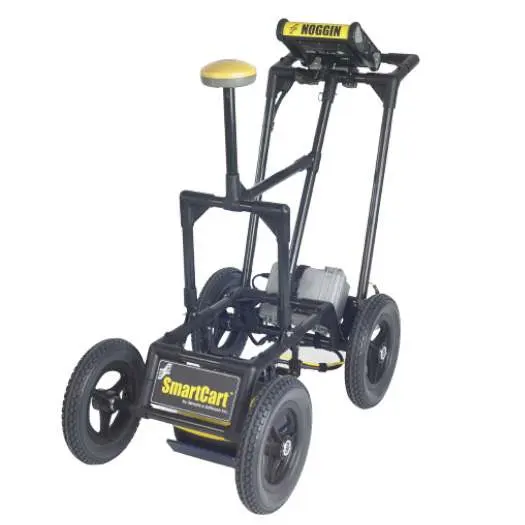
Radiodetection Noggin 500 SmartCart | 500 MHz GPR System | Subsurface Utility Mapping
The Radiodetection Noggin 500 SmartCart System is a professional-grade ground penetrating radar (GPR) solution engineered for high-resolution subsurface investigations. Utilizing a precision 500 MHz NOGGIN sensor, this system provides accurate imaging for utility mapping and infrastructure assessment. Its durable, 4-wheeled folding SmartCart design is specifically optimized for mobility, allowing for rapid and efficient data collection across diverse environmental terrains.
How does the 500 MHz sensor improve mapping?
The 500 MHz frequency provides a critical balance between depth penetration and high-resolution imaging, allowing for the precise detection of mid-depth utilities. This frequency is specifically calibrated for subsurface utility mapping where detail and depth are both essential.
What terrain is the SmartCart design suited for?
The 4-wheeled folding SmartCart is designed for stability and reliability on various terrains, ensuring the sensor maintains consistent ground coupling. Its folding design allows for quick deployment and easy transport between investigation sites.
Why choose the Noggin 500 for utility mapping?
This system is a reliable choice for professionals because it integrates a high-performance GPR sensor with a ruggedized carrier for high-speed data acquisition. The Noggin 500 ensures high-quality data results even in challenging field environments.
| Manufacturer | Radiodetection |
| Model | Noggin 500 SmartCart System |
| Sensor Frequency | 500 MHz |
| Carrier Type | 4-wheeled Folding SmartCart |
| Primary Function | Ground Penetrating Radar (GPR) |
| Application | Subsurface Utility Mapping |
- Integrate the Noggin Display (DVL-500) for real-time data visualization during mapping.
- Maintain connection with the DVL to Noggin SmartCart Cable with Latches.
- Enhance positioning accuracy using the Noggin 500 Odometer with Bracket.
- Process your subsurface data with the EKKO_Project V6 Core Software Bundle.