
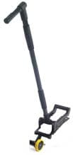
Radiodetection Noggin 1000 SmartHandle Configuration (DVL-500) | High-Resolution GPR Mapping
The Noggin 1000 SmartHandle Configuration (DVL-500) is a specialized ground penetrating radar (GPR) solution designed for professionals who require ultra-high-resolution data in restricted or confined areas. By integrating a 1000 MHz NOGGIN sensor with the proprietary SmartHandle system, this configuration provides a lightweight, maneuverable platform that maintains exceptional data integrity while navigating complex site conditions.
What are the primary applications for the Noggin 1000 SmartHandle?
This system is optimized for high-resolution subsurface mapping where space is limited, such as interior building inspections and utility vault surveys. The 1000 MHz frequency allows for the detection of shallow, small-diameter targets with extreme precision.
How does the SmartHandle system enhance GPR surveys?
The SmartHandle provides a compact and lightweight frame that allows the operator to easily push or pull the sensor over various terrain types. This setup ensures the Noggin 1000 remains stable and properly oriented for consistent data collection in tight spots.
Is the DVL-500 configuration suitable for rough terrain?
Yes, the versatile design is engineered to function reliably in a variety of challenging environments. The system's lightweight construction does not compromise its durability, making it a must-have for field professionals requiring a rugged yet portable GPR unit.
| Attribute | Specification |
| SKU | 100-53-0118-UK |
| Sensor Frequency | 1000 MHz |
| Compatible Display Unit | DVL-500 |
| Configuration Type | SmartHandle |
| Primary Benefit | High-Resolution Subsurface Mapping |
| Maneuverability | Push/Pull Versatility |
- Maintain high-resolution data with the Noggin 1000 Unit.
- Review real-time mapping data on the Noggin Display (DVL-500).
- Enhance operator comfort during long surveys with the DVL-500 Carry Harness.