

Underground cable locators are invaluable tools in a variety of sectors, including construction, telecommunications, and utilities. These specialized devices employ cutting-edge technology to accurately detect and pinpoint the location of underground cables. This is crucial for ensuring the safety of workers and for protecting existing infrastructure from accidental damage. This comprehensive guide aims to delve deep into the importance of underground cable locators, the different types available, the challenges professionals face, and the future trends that are shaping this field.
The Indispensable Role of Underground Cable Locators
The primary function of cable locators is to prevent accidental damage to underground utilities during excavation or construction activities. The consequences of inadvertently cutting through live electrical or telecommunication cables can be severe, ranging from costly service outages to potential legal liabilities and even life-threatening injuries. By providing precise information about the location of these underground cables, cable locators significantly mitigate such risks, thereby saving both time and money.
Time and Cost Efficiency: The Financial Upside
The traditional methods of locating underground cables often involve a lot of trial and error, which can be both time-consuming and expensive. In contrast, cable locators streamline this process by providing accurate, real-time data. This enables businesses to allocate their resources more efficiently, thereby reducing operational costs and ensuring that projects are completed within their timelines.
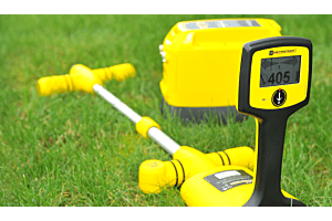
Types of Underground Cable Locators and Their Applications
Choosing the right type of cable locator is crucial for the success of your project. Here are some commonly used types and their specific applications:
- Electromagnetic Locators: These are the most commonly used and are ideal for locating metallic cables and pipes. They are often used in utility detection, route tracing, and depth estimation.
- Acoustic Locators: These are best suited for locating plastic pipes that are filled with water. They are commonly used in water and gas industries.
- Ground Penetrating Radar (GPR): This is a versatile tool useful for a wide range of applications. It is particularly effective for locating non-metallic cables and is often used in more complex locating tasks involving diverse materials.
Understanding the specific needs of your project can help you choose the most appropriate type of cable locator.
Challenges in Cable Locating and Pre-Survey Checks
Locating underground cables is fraught with challenges. These can range from outdated or inaccurate records and maps to electromagnetic interference from other nearby utilities. Even the soil conditions, such as its moisture content and mineral composition, can affect the accuracy of cable locators.
Before embarking on any cable locating project, it's crucial to conduct pre-survey checks. This involves:
- Reviewing any available utility maps or records for the area.
- Visually inspecting the site for signs of existing utilities like manhole covers, valve boxes, or utility markers.
- Using your cable locator to perform a preliminary sweep of the area to identify any obvious utilities.
Methods for Effective Cable Locating
Different projects may require different cable locating methods. Here are some commonly used techniques:
- Electromagnetic Detection: This is effective for locating metallic cables and involves using a transmitter to send a signal along the cable, which is then detected by a receiver.
- Acoustic Detection: This method uses sound waves to locate cables. A transmitter sends out a high-frequency sound wave that travels along the cable, and a receiver detects any vibrations or disturbances caused by the sound wave.
- Ground Penetrating Radar (GPR): This uses radio waves to create images of what lies below the surface. It is particularly useful when dealing with non-metallic or non-conductive cables.
Each of these methods has its own set of advantages and limitations, and often, a combination of these methods yields the most accurate results.
Best Practices and Troubleshooting Tips for Underground Cable Locators
Effective cable locating requires adherence to certain best practices:
- Read the User Manual: Always start by reading the user manual to understand the capabilities and limitations of your equipment.
- Conduct Pre-Survey Checks: As mentioned earlier, always conduct a preliminary survey to identify potential challenges.
- Regular Calibration: Ensure that your equipment is calibrated according to the manufacturer's guidelines to maintain its accuracy.
If you encounter issues during the locating process, consider the following troubleshooting tips:
- Verify that your equipment is properly calibrated and functioning correctly.
- Recheck any pre-survey information or utility maps you have for the area.
- Consider environmental factors like soil composition and adjust your equipment settings accordingly.
Conclusion
Underground cable locators are not just tools but essential assets for any project involving excavation or construction. Their role in ensuring safety and efficiency cannot be overstated. As technology advances, we can expect even more accurate and versatile cable locators to come into the market.
Next Step
Ready to invest in a reliable and advanced underground cable locator? Explore our range of high-quality products tailored to meet your specific needs. View Our Products Here.
FAQs
- What is the importance of underground cable locators?
Underground cable locators are essential for preventing damage to underground utilities, ensuring safety during excavation projects, and saving time and money by accurately locating cables without the need for trial and error.
- What are some common challenges faced in locating underground cables?
Common challenges include inaccurate or outdated utility maps, interference from nearby utilities, signal distortion caused by different soil conditions, and the presence of non-metallic or non-conductive cables.
- What are the types of underground cable locating methods?
There are various methods used for underground cable locating, including electromagnetic (EM) detection, ground penetrating radar (GPR), acoustic methods, and tracer wire systems.
- What is the role of ground penetrating radar (GPR) in cable detection?
GPR is a non-destructive method that uses high-frequency radar signals to detect and map underground objects, including cables. It can provide accurate depth measurements and identify different types of cables.
- What factors should be considered when choosing an underground cable locator?
Factors to consider include the type of cables being located, the accuracy and depth range required, the soil conditions, the ease of use and portability of the equipment, and the availability of technical support and training.
- Are there any training and certification programs for cable locating professionals?
Yes, there are training and certification programs available for cable locating professionals. These programs provide the necessary knowledge and skills to effectively and safely use underground cable locating equipment.
- Can you provide examples of successful cable locating projects?
Yes, there are numerous case studies available that highlight successful cable locating projects. These examples demonstrate the importance of using accurate and advanced technology to locate underground cables efficiently.
- What are some tips for troubleshooting cable locating issues?
Some tips for troubleshooting cable locating issues include checking the equipment for any malfunctions or calibration errors, ensuring proper grounding and signal strength, and referring to the user manual or seeking technical support if needed.
- What are the future trends in underground cable locating technology?
Future trends in underground cable locating technology include advancements in real-time mapping and augmented reality systems, improved integration with GIS platforms, enhanced accuracy and sensitivity of detection equipment, and the development of wireless and remote-controlled systems.


Login and Registration Form